Flight Planner
Flight Planner
The most recommended package for both VFR and IFR flight planning in Australia.
Designed specifically for pilots, you will quickly become an expert flight planner with more time to fly.


Command Flight Planner is the premier PC based aviation flight planner for general pilots and small air operators in Australia. With its superior functions to calculate track, distance, wind and time intervals, weight and balance, fuel usage, integrate weather and submit flight plans via NAIPS, it makes flight planning easier than ever.
Features and Benefits
- Airservices Australia supplied data updated quarterly, so you are always up to date
- Complete preparation of all aspects of Australian and ICAO flight plans, from plan conception to plan submissions and in flight use
- 'Join the dots' or interactive waypoint selection
- Google Earth interface for viewing your flight plans
- IFR and VFR modes for flexibility and ease of use
- Download and view GAF Forecast and GPWT winds
- All track/distance/wind/time interval calculations fully automated and instantly updated when anything is changed
- Automatic ICAO cruising levels, with automated plan optimisation facility (considers MET conditions, route data and aircraft performance to recommend optimal altitudes)
- All fuel calculations, weight and balance, CP/PNR, flight costings, first/last light, abeam waypoints, alternates and more
- Inbuilt automated backup system to protect your user defined aircraft, waypoint, LSALT and other data
- Supports flight plans to anywhere in the world
- Comprehensive user guide and step by step tutorial
Waypoint Data
- Enormous waypoint database containing every Australian licensed airport, IFR and VFR reporting point, GPS waypoints, as well as hundreds of ALA's
- Place names database with over 25,000 Australian place names and population centres
- Optional 200,000 point Australian place names database comprising lakes, railway sidings, homesteads, mountain peaks, mine sites, rivers, hills, sand bars, ridges and much more
- Extensive airport diagram database that includes 'drag and drop' airport diagram builder for adding your own airport diagrams
IFR Features
- FULLY automated application of route designators. Just enter the waypoints and any applicable routes will be automatically identified, along with any intermediary reporting points.
- Automated marking of mandatory IFR reporting points.
- Massive database of thousands of recommended routes. Just enter your departure and destination waypoint and the route options are automatically applied.
- Automatic arrival/departure via navaids.
- Automated application of LSALT's from Australia wide LSALT database.
VFR Features
- Special VFR mode allowing VFR plans to be prepared quickly and easily without wading through IFR specific details
- Automatic ICAO VFR altitude assignments
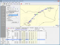
Map Display
- Route graphically displayed with colour coding of route to show the top of climb and descent points
- Google Earth interface to view your plan over actual terrain
- Unlimited zoom in/out through simple mouse control
- Interactive bearing/distance calculator
- Airspace displays show CTA, PRD, FIA, CTAF, ARFOR, FIA, HF boundaries in relation to your route. fine tune by displaying airspace within a given altitude range (e.g. below 10,000). Pop up window shows full details of any airspace region
- Simple mouse driven tools for identifying waypoints within any given area, or 15 degrees either side of track
- Click on any waypoint for on screen display of airport/navaid data, airport diagram etc.
- Click on any airspace region to see controlling authority, altitude limits, hours of activation etc.
Aircraft
- Extensive 'Aircraft Type Library' contains dozens of popular aircraft from Cessna 152 to Citation Jets which you can use as templates for your own aircraft
- Supports multiple configuration for each aircraft (eg. different power/weight config, IFR/VFR, club seating etc.)
- Unlimited scope to enter user defined aircraft profiles
- Performance profiles with an unlimited number of steps for high performance aircraft.
- Flexible weight and balance, configure for weight/arm or weight/moment loading systems. Unlimited number of load and fuel stations
- 'Quick Aircraft' facility allows fast start with a new aircraft
- Full passenger manifest facility with printed load sheet
- Import and export aircraft for easy transfer and backup
NAIPS Link
- Interface to NAIPS is supported - area/location briefings (including GAF and GPWT data), general MET, special MET, wind/temp profiles, SPFIB, Routes, GPS Raim, flight file, charts, domestic/ICAO/Sartime plan submission, first/last light etc.
- 'One click' MET/NOTAM briefings - your plan is analysed and all necessary MET and NOTAM data are automatically downloaded. All wind data is integrated into your plan (upper and lower level winds) and summarised for viewing and printing
- 'One click' plan submission - your plan is validated and submitted automatically. You also have the ability to make last minute adjustments to the submitted data
GPS Link
- Upload flight plan routes and user defined waypoints to your GPS
- Supports virtually all GPS models, including serial and USB connection
- Export your route to Garmin FPL file for Garmin G1000 and similar devices
- Export your route to GPX format for use in Garmin Aera 500 devices and other programs
- Download user defined waypoints from your GPS to Command Flight Planner
Printouts
- Quality printouts utilising the maximum capabilities of your printer
- Flight notification forms
- Enroute data sheet with airport and waypoint data including airport diagrams
- Pilots domestic flight plan form in portrait and landscape styles with user configurable areas for traffic, ATIS, clearances etc.
- Jeppesen style IFR flight log with all frequency and navaid data, morse ident, fuel log, route data etc.
- VFR flight note
- Load sheet showing C of G envelope, detailed loading information and passenger manifest
- Printouts of NAIPS generated MET and NOTAM data relevant to your flight.
- Aircraft data printouts
Updates
- Annual subscription service includes all program updates, data updates and documentation
- 'My Account' screen lets you view your account status, find out if there are any program updates, and automatically download and install updates, right from within the program. No need to use your browser to download updates from a web site.
Flexible Licensing & Support
- Licensed for installation on a single PC (one licence - one computer)
- Initial purchase includes data updates for three months
- Quick and easy installation
- Free email support
System Requirements
- Windows 10 preferred. Earlier versions of Windows are nolonger supported.
- You will require an internet connection to use the NAIPS Link and to download the software.
- Where is the Mac, iPhone, iPad, Android, Windows Phone version?
- Command Flight Planner is not compatibile with tablets running Windows RT.
Please note: This is a downloadable software product and does not include a delivered CDROM or printed manual.
Price: $129.00